


Revolutionize Precision Mapping with the DJI Phantom 4 RTK
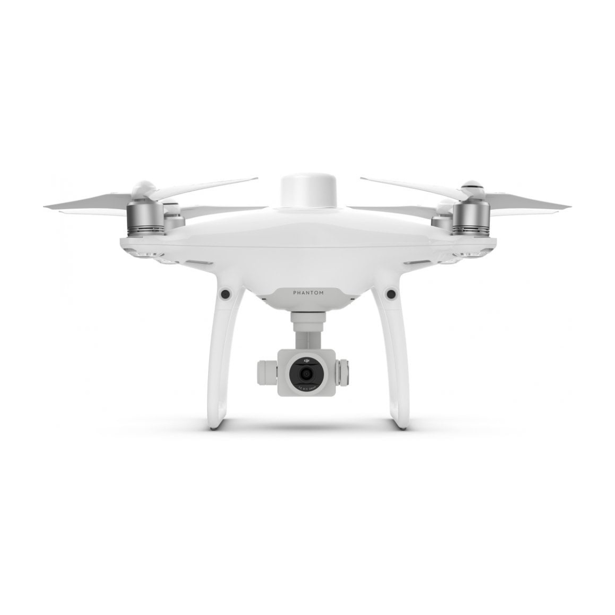
The DJI Phantom 4 RTK represents the pinnacle of aerial surveying and mapping technology, designed for professionals who demand the highest level of accuracy and efficiency. Packed with advanced features, this drone delivers unmatched precision, making it an indispensable tool for industries requiring accurate geospatial data collection.
Discover Game-Changing Innovations
Step into the future of drone technology with groundbreaking capabilities designed to elevate your aerial missions. Experience unmatched performance and advanced features that redefine what's possible.
Unparalleled RTK Precision
Achieve centimeter-level accuracy with the Phantom 4 RTK's integrated Real-Time Kinematic (RTK) module. It syncs seamlessly with the TimeSync system, ensuring precise geospatial data collection for critical surveying and mapping tasks.
High-Performance Camera
The drone features a 1-inch, 20MP CMOS sensor, capable of capturing high-resolution images with exceptional clarity. Its mechanical shutter eliminates rolling shutter distortion, making it ideal for aerial mapping and photogrammetry.
Efficient Data Management
The Phantom 4 RTK integrates smoothly with the DJI GS RTK app and third-party mapping software, enabling efficient mission planning and data collection. Built-in compatibility with PPK (Post Processed Kinematics) workflows offers added flexibility for post-flight analysis.
Extended Flight Time and Range
With a flight time of up to 30 minutes and a range of up to 7 kilometers, the Phantom 4 RTK allows you to cover large areas efficiently. This extended operational capacity minimizes downtime and maximizes productivity.
Streamlined Workflow
The drone is designed to simplify complex surveying tasks. Its mission planning tools include waypoints, linear missions, and block area mapping, ensuring seamless operation for users of all experience levels.
Durable and Reliable Design
Built with industrial-grade components, the Phantom 4 RTK is engineered to withstand challenging environments while maintaining consistent performance. Its compact, foldable design makes it easy to transport, perfect for professionals on the move.
Transform Your Operations Across Industries
Revolutionize how you work with versatile solutions tailored for diverse professional applications. From precision mapping to critical inspections, explore the endless possibilities this drone unlocks.
Precision Agriculture
- Capture high-resolution imagery to analyze soil health, irrigation patterns, and vegetation growth.
- Equip farmers with actionable data to improve crop yield and resource efficiency.
Infrastructure Inspections
- Perform detailed inspections of bridges, power lines, and construction sites with precision.
- Leverage advanced imaging capabilities for quick issue identification and detailed reporting.
Urban Planning and Land Development
- Gather topographical data to create accurate 3D models for city planning and construction projects.
- Ensure precise measurements and seamless collaboration among project stakeholders.
Environmental Monitoring
- Monitor deforestation, wildlife habitats, and environmental changes with minimal disruption.
- Collect detailed aerial data to support environmental research and conservation efforts.
Disaster Response and Management
- Rapidly map disaster zones to assist in emergency scenarios.
- Provide real-time geospatial data to aid first responders in effective relief planning and execution.
Elevate Your Operations with the DJI Phantom 4 RTK
The DJI Phantom 4 RTK sets a new standard in professional drone technology, offering unmatched precision and efficiency for a wide range of applications. Whether you're in agriculture, construction, environmental research, or public safety, this drone empowers you to make informed decisions and achieve better outcomes.
Experience the next level of aerial mapping and data collection today with the DJI Phantom 4 RTK.
Why Choose DSLRPros?
At DSLRPros, we deliver advanced drone solutions tailored for professional needs.
- Customized Offerings: Drones and tools designed for industries like public safety and construction.
- Specialized Expertise: Solutions crafted for your unique operational challenges.
- Top-Tier Equipment: Featuring high-performance drones like DJI Phantom.
- Data Security Focus: Scalable, compliant systems for reliable data management.
- Comprehensive Support: Training to ensure you get the most from your investment.
We’re here to help you achieve operational success with confidence
Specifications
Aircraft
- Takeoff weight: 1391 g
- Diagonal distance: 350 mm
- Max service ceiling above sea level: 19685 ft (6000 m)
- Max ascent speed: 6 m/s (automatic flight); 5 m/s (manual control)
- Max descent speed: 3 m/s
- Max speed: 31 mph (50 kph) (P-mode); 36 mph (58 kph) (A-mode)
- Max flight time: Approx. 30 minutes
- Operating temperature range: 32° to 104° F (0° to 40°C)
- Operating frequency: 2.400 GHz to 2.483 GHz (Europe, Japan, Korea); 5.725 GHz to 5.850 GHz (United States, China)
- Transmission power (EIRP): 2.4 GHz CE (Europe) / MIC (Japan) / KCC (Korea): < 20 dBm; 5.8 GHz SRRC (China) / FCC (United States) / NCC (Taiwan, China): < 26 dBm
-
Hover accuracy range:
- RTK enabled and functioning properly: Vertical: ±0.1 m; Horizontal: ±0.1 m
- RTK disabled: Vertical: ±0.1 m (with vision positioning); ±0.5 m (with GNSS positioning); Horizontal: ±0.3 m (with vision positioning); ±1.5 m (with GNSS positioning)
- Image position offset: The position of the camera center is relative to the phase center of the onboard D-RTK antenna under the aircraft body’s axis (36, 0, and 192 mm) already applied to the image coordinates in Exif data. The positive x, y, and z axes of the aircraft body point to the forward, rightward, and downward directions of the aircraft, respectively.
Mapping functions
-
Mapping accuracy: Mapping accuracy meets the requirements of the ASPRS Accuracy Standards for Digital Orthophotos Class Ⅲ.
** The actual accuracy depends on surrounding lighting and patterns, aircraft altitude, mapping software used, and other factors when shooting. - Ground sample distance (GSD): (H/36.5) cm/pixel, where H means the aircraft altitude relative to the shooting scene (unit: m)
- Data acquisition efficiency: Max operating area of approx. 1 km² for a single flight (at an altitude of 182 m, i.e., GSD is approx. 5 cm/pixel, meeting the requirements of the ASPRS Accuracy Standards for Digital Orthophotos Class Ⅲ)
Vision system
- Velocity range: ≤31 mph (50 kph) at 6.6 ft (2 m) above ground with adequate lighting
- Altitude range: 0-33 ft (0-10 m)
- Operating range: 0-33 ft (0-10 m)
- Obstacle sensing range: 2-98 ft (0.7-30 m)
- FOV: Forward/rear: 60° (horizontal), ±27° (vertical); Downward: 70° (front and rear), 50° (left and right)
- Measuring frequency: Forward/rear: 10 Hz; Downward: 20 Hz
- Operating environment: Surfaces with clear patterns and adequate lighting (>15 lux)
Camera
- Sensor: 1" CMOS; Effective pixels: 20 M
- Lens: FOV 84°; 8.8 mm / 24 mm (35 mm format equivalent: 24 mm; f/2.8 - f/11, autofocus at 1 m to ∞)
- ISO range: Video: 100-3200 (Auto), 100-6400 (Manual); Photo: 100-3200 (Auto), 100-12800 (Manual)
- Mechanical shutter speed: 8 - 1/2000 s
- Electronic shutter speed: 8 - 1/8000 s
- Max image size: 4864×3648 (4:3); 5472×3648 (3:2)
- Video recording modes: H.264, 4K: 3840×2160 30p
- Photo format: JPEG
- Video format: MOV
- Supported file systems: FAT32 (≤32 GB); exFAT (>32 GB)
- Supported SD cards: MicroSD, max capacity: 128 GB. Class 10 or UHS-1 rating required, write speed ≥ 15 MB/s
- Operating temperature range: 32° to 104° F (0° to 40°C)
Intelligent flight battery (PH4-5870MAH-15.2V)
- Capacity: 5870 mAh
- Voltage: 15.2 V
- Battery type: LiPo 4S
- Energy: 89.2 Wh
- Net weight: 468 g
- Charging temperature range: 14° to 104° F (-10° to 40°C)
- Max charging power: 160 W
Intelligent battery charging hub (WCH2)
- Input voltage: 17.3 - 26.2 V
- Output voltage and current: 8.7 V, 6 A; 5 V, 2 A
- Operating temperature: 41° to 104° F (5° to 40°C)
GNSS
- Single-frequency, high-sensitivity GNSS module: GPS+BeiDou+Galileo (Asia); GPS+GLONASS+Galileo (other regions)
-
Multi-frequency multi-system high-precision RTK GNSS: Frequency used:
- GPS: L1/L2
- GLONASS: L1/L2
- BeiDou: B1/B2
- Galileo: E1/E5a
- First-fixed time: < 50 s
- Positioning accuracy: Vertical: 1.5 cm + 1 ppm (RMS); Horizontal: 1 cm + 1 ppm (RMS) [1 ppm means the error has a 1 mm increase for every 1 km of movement from the aircraft]
Gimbal
- Stabilization: 3-axis (tilt, roll, yaw)
- Pitch: -90° to +30°
- Max controllable angular speed: 90°/s
- Angular vibration range: ±0.02°
Infrared
- Obstacle sensing range: 0.6-23 ft (0.2 - 7 m)
- FOV: 70° (Horizontal); ±10° (Vertical)
- Measuring frequency: 10 Hz
- Operating environment: Surface with diffuse reflection material and reflectivity > 8% (such as walls, trees, humans, etc.)
Remote controller
- Operating frequency: 2.400 GHz - 2.483 GHz (Europe, Japan, Korea); 5.725 GHz - 5.850 GHz (United States, China)
- Transmission power (EIRP): 2.4 GHz CE / MIC / KCC: < 20 dBm; 5.8 GHz SRRC / FCC: < 26 dBm
- Max transmission distance: FCC: 4.3 mi (7 km); SRRC / CE / MIC / KCC: 3.1 mi (5 km) (unobstructed, free of interference)
- Power consumption: 16 W (typical value)
- Display: 5.5-inch screen, 1920×1080, 1000 cd/m², Android system; Memory: 4G RAM + 16G ROM
- Operating temperature range: 32° to 104° F (0° to 40°C)
Intelligent flight battery charging hub (Phantom 4 charging hub)
- Voltage: 17.5 V
- Operating temperature range: 41° to 104° F (5° to 40°C)
- Capacity: 4920 mAh
- Voltage: 7.6 V
- Battery type: LiPo 2S
- Energy: 37.39 Wh
- Operating temperature: -4° to 104° F (-20° to 40°C)
AC power adapter (PH4C160)
- Voltage: 17.4 V
- Rated Power: 160 W
In the Box
- 1x DJI Phantom 4 RTK (no Base Station included)

