


Autel EVO II Dual 640T RTK Rugged Bundle V3
Autel EVO II Dual 640T RTK Rugged Bundle V3
SKU:S-AR-E2DT-RTK


- Description
- Specifications
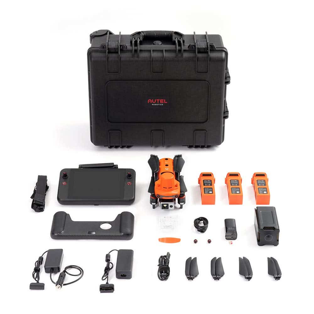
- In the Box
- FAQ
Autel EVO II Dual 640T RTK Rugged Bundle V3: High-accuracy thermal mapping for enterprise operations
The Autel EVO II Dual 640T RTK V3 sets a new standard for aerial technology, building on the strengths of its predecessor with the integration of a state-of-the-art RTK module and significant advancements. Designed to enhance efficiency and accuracy, this drone is your ultimate partner for demanding aerial missions.
Key Features and Benefits
- Dual-sensor payload: 50 MP visual camera and radiometric 640 × 512 thermal unit.
- Integrated RTK module: delivers centimeter-level accuracy and PPK support.
- High-resolution capture: large 0.8″ sensor improves detail and mapping quality.
- Thermal imaging tools: 16× zoom, 10 palettes, and radiometric measurement modes.
- Up to 42 minutes flight time: measured under no-wind, accessory-free conditions.
- Strong wind resistance: stable up to 20 m/s in challenging outdoor environments.
- Full 360° obstacle detection: 19 sensor groups increase safety near structures.
- Up to 15 km transmission: stable SkyLink 2.0 communication link.
- Rugged field equipment: spare batteries, chargers, and hardened case included.
- Encrypted data workflow: protects sensitive thermal and visual mission files.
The EVO II Dual 640T RTK V3 retains critical data such as camera exposure settings and original satellite observation files, offering greater flexibility for post-mission analysis. Its positioning system integrates seamlessly with the NTRIP RTK network and RTK base stations, enabling precise and stable operations even in challenging environments.
Dual Cameras for Versatile Mission Capabilities
Featuring both thermal and visual cameras, the EVO II Dual 640T RTK V3 empowers operators to perform a wide range of missions with a single, powerful platform. From routine overhead imaging to advanced applications like area mapping, infrastructure inspection, search and rescue, or crowd monitoring, this drone adapts to your needs effortlessly.
- 640T Thermal Camera
The drone's thermal imaging system includes a 640×512 resolution camera operating at 30Hz with a 13mm focal length lens and 16x digital zoom, allowing you to observe distant targets with clarity. The enhanced image processing algorithm delivers superior detail and definition compared to competitors, even with similar hardware specifications.
- 50-Megapixel Ultra-Sensitive Visual Camera
The visual camera leverages an advanced RYYB sensor and Autel’s Moonlight Algorithm 2.0 to capture crisp, high-resolution imagery. This 50-MP camera provides enhanced forensic and analytical capabilities, even in low-light conditions.
With integrated PDAF (Phase Detection Auto Focus) and CDAF (Contrast Detection Auto Focus), users can quickly and accurately track targets, ensuring reliable results. The combination of thermal and visual imaging enables you to process data efficiently and make informed decisions.
Peak Performance Meets Unmatched Safety
With Autel’s cutting-edge SkyLink 2.0 Video Transmission technology, the EVO II Dual 640T RTK V3 achieves a transmission range of up to 15 kilometers. The robust battery ensures up to 40 minutes of flight time, enabling extended operations without compromising performance.
The drone provides critical QHD video transmission within a one-kilometer radius and employs tri-band communication with frequency hopping to counter interference effectively.
Safety is paramount, with 19 sensors—including 12 visual sensors, ultrasonic sensors, and IMUs—that work together to enable 3D mapping and real-time path planning, ensuring safe and reliable flights in dynamic environments.
Smart and Intuitive Control System
The EVO II Dual 640T RTK V3 is paired with the Smart Controller SE, featuring an 8-core processor and a 6.4-inch OLED touchscreen for seamless HD transmission.
SkyLink 2.0 technology enhances anti-interference capabilities through triple-band frequency hopping, enabling long-range operations up to 15 kilometers. Additionally, the controller's modified Android OS supports third-party applications, providing flexibility for custom workflows.
With an IP43 rating, the Smart Controller SE is built for reliability in diverse weather conditions, ensuring consistent performance in the field.
Applications & Use Cases
From agriculture to search and rescue, firefighting to law enforcement, the Autel EVO II Dual 640T RTK V3 is designed to meet the demands of industry professionals across a wide spectrum of applications.
- Search & Rescue: Thermal imaging and long-range visibility support locating persons in difficult terrain or low light.
- Infrastructure Inspection: Capture detailed thermal and visual data for asset monitoring and damage detection.
- Firefighting & Public Safety: Detect hotspots during disasters while maintaining safe stand-off distance.
- Agriculture & Environmental Surveys: Leverage dual imaging to monitor crop health, irrigation, and wildlife.
- Crowd Monitoring & Security: Autonomous tracking paired with high-resolution zoom enables responsive situational awareness.
This rugged platform is engineered for demanding field conditions and extended mission cycles.
Its integrated RTK capabilities, strong wind resistance, and thermal/visual dual-sensor design enable reliable data collection across diverse industries. The hardened case, spare batteries, chargers, and rapid-deployment airframe support long field days.
The Autel EVO II Dual 640T RTK Rugged Bundle V3 offers precise imaging, reliable thermal performance, and RTK accuracy for enterprise-grade mapping, inspection, and response missions.
Its rugged accessories and secure data workflow ensure consistent results across professional environments.
