


Innovative Software Solutions for Precision and Efficiency with GreenValley International's software suite
GreenValley International's software suite, including LiPowerline and LiDAR360, represents the cutting edge in drone technology for inspections and advanced point cloud processing. Designed to revolutionize the way industries gather, analyze, and act on critical data, these tools provide an integrated approach to streamlining workflows and enhancing operational accuracy.
Smarter Powerline Inspections with LiPowerline
LiPowerline redefines the powerline inspection process by blending automation with precise manual controls, offering unparalleled capabilities to professionals tasked with maintaining critical infrastructure.
-
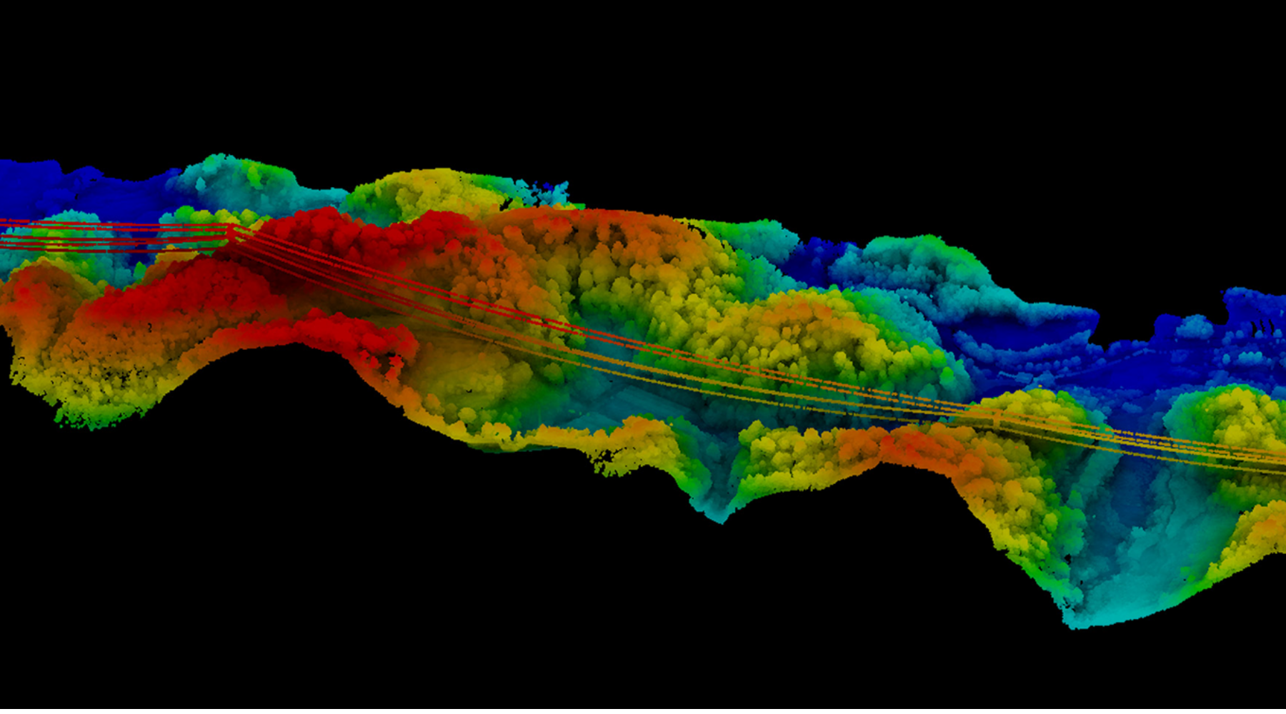
Simplified Point Cloud Classification: Leveraging both automatic and manual classification, LiPowerline enables users to identify powerline components, surrounding vegetation, and structural hazards with minimal effort. Its intuitive controls allow operators to fine-tune classifications, ensuring pinpoint accuracy for every inspection.
-
Advanced Hazard Detection: Through deep learning algorithms, LiPowerline identifies potential risks such as overhanging branches, unstable structures, or vegetation encroachment. These insights are critical for proactive maintenance and minimizing outages.
-
Predictive Modeling for Enhanced Safety: One of LiPowerline’s standout features is its ability to simulate environmental impacts like high winds, ice loading, or tree falls. By modeling these scenarios, users can anticipate potential failures and reinforce vulnerable areas before issues arise.
-
Efficiency Meets Insight: With its automation capabilities, LiPowerline significantly reduces the time needed for inspections while delivering richer, more detailed data. Whether managing sprawling transmission networks or localized power grids, the software empowers utility companies to operate with heightened confidence.
Comprehensive Point Cloud Management with LiDAR360
For industries reliant on accurate LiDAR data, LiDAR360 sets the benchmark for advanced processing, classification, and vectorization.
-
Dynamic Preprocessing and Classification: LiDAR360 simplifies the daunting task of processing massive point clouds. With tools for feature detection and classification, users can seamlessly sort terrain, vegetation, and structures, ensuring clean, actionable data.
-
Multi-Source Data Integration: Combining CAD, GIS, and LiDAR data, the software allows users to create holistic models that provide unparalleled insights. This is particularly useful for urban planning, mining surveys, and forestry resource management.
-
Smart Editing Tools for Versatility: The platform includes tools for editing, vectorizing, and visualizing data, making it easier to generate digital terrain models (DTMs), detect encroachment, and monitor land changes over time.
-
Industry-Leading Algorithms: LiDAR360’s advanced algorithms enhance accuracy while reducing processing times, ensuring users can tackle even the most complex projects efficiently.
Applications That Go Beyond Expectations
GreenValley International’s software products are not confined to a single industry. Instead, they extend their capabilities across diverse sectors, bringing innovation and reliability to professionals worldwide.
-
Utility Companies: LiPowerline aids in maintaining powerline networks by detecting vegetation hazards and ensuring structural integrity, minimizing outages and ensuring public safety.
-
Forestry and Environmental Monitoring: LiDAR360 supports large-scale forestry assessments and environmental monitoring by providing tools to map resources, measure tree canopies, and track ecosystem changes.
-
Geological and Topographic Surveys: Whether surveying mines or creating topographic maps, LiDAR360’s precision ensures accurate modeling for safe and efficient operations.
-
Urban Planning and 3D Modeling: In urban settings, the software excels at generating detailed 3D models for infrastructure planning, land-use analysis, and disaster preparedness.
Why GreenValley's Solutions Are Essential
GreenValley’s software transforms how industries leverage drone technology. By integrating predictive tools, advanced classification algorithms, and seamless data management, LiPowerline and LiDAR360 provide actionable insights that drive safer, smarter decisions.
At DSLRPros, we’re committed to helping professionals unlock the full potential of these tools. From ensuring powerline safety to managing vast forestry resources, GreenValley’s software solutions are the key to enhancing operational precision and efficiency.
Explore our offerings to discover how GreenValley’s cutting-edge software can elevate your drone-based projects to new heights.
