


Revolutionizing Aerial Surveys with the DJI Mavic 3 Multispectral
The DJI Mavic 3 Multispectral combines precision imaging and advanced technology to meet the needs of professionals in agriculture, surveying, and inspection. Designed for accuracy and efficiency, this drone features multispectral imaging, enhanced connectivity, and industry-leading data capabilities. Compact, portable, and powerful, it sets a new standard for aerial data collection and analysis.
Advanced Imaging for In-Depth Insights
The Mavic 3 Multispectral offers a comprehensive imaging system tailored to professionals who demand high-precision data for critical decision-making:
- 20MP RGB Camera: Captures high-resolution images and video in visible light, ensuring detailed and accurate visuals for mapping, inspections, and analysis.
- Four Multispectral Cameras: Includes Green, Red, Red Edge, and Near Infrared (NIR) spectrums, each with 5MP resolution. These cameras are essential for assessing vegetation health, identifying stress patterns, and conducting environmental analysis with precision.
- Mechanical Shutter: A fast 1/2000s mechanical shutter eliminates motion blur, supporting high-speed burst shooting at 0.7-second intervals in RGB mode for quick and accurate data collection.
This advanced imaging system provides a complete visual and spectral dataset, making it indispensable for modern farming, terrain mapping, and structural assessments.
Precision Agriculture with Multispectral Imaging
The Mavic 3 Multispectral is a game-changer for agriculture professionals:
- Crop Health Assessment: Multispectral cameras analyze plant health by detecting stress indicators, nutrient levels, and water availability. This helps optimize resource allocation, improving yields and sustainability.
- Field Mapping and Monitoring: Conduct large-scale field surveys with centimeter-level accuracy, enabling better planning for irrigation, fertilization, and pest management.
- Solar Irradiance Compensation: A built-in sunlight sensor records real-time solar irradiance, ensuring accurate Normalized Difference Vegetation Index (NDVI) readings and consistent data quality across varied lighting conditions.
From small farms to expansive agricultural operations, the Mavic 3 Multispectral delivers actionable insights to boost productivity and reduce costs.
Surveying and Inspections Taken to the Next Level
For surveyors and inspection professionals, this drone offers features that streamline operations in challenging environments:
- RTK Precision: Equipped with an RTK module, the drone synchronizes flight control and camera systems for centimeter-level accuracy, reducing the need for ground control points. This feature is invaluable for steep slope surveys, urban planning, and construction site assessments.
- Terrain-Following Capability: The drone’s real-time terrain analysis adapts to uneven landscapes, maintaining consistent altitude and capturing accurate data even in rugged conditions.
- Hybrid Imaging Tools: The combination of RGB and multispectral imaging enhances inspections, allowing for structural assessments, vegetation monitoring, and thermal anomaly detection in a single mission.
Whether mapping hazardous sites or conducting aerial inspections, the Mavic 3 Multispectral ensures precise results with reduced operational risk.
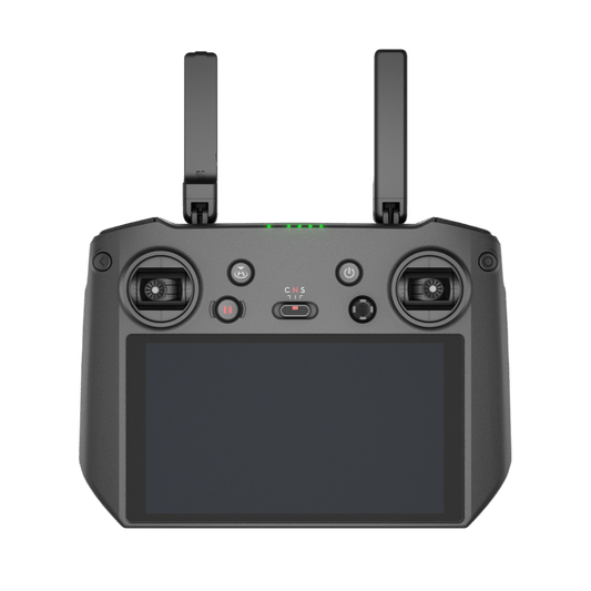
Smart Connectivity for Seamless Integration
The Mavic 3 Multispectral is designed for connectivity and adaptability:
- Cloud API Integration: Directly connects to third-party cloud platforms via DJI Pilot 2, eliminating the need for custom app development. This simplifies data management and enhances workflow efficiency.
- Mobile SDK Compatibility: Fully compatible with Mobile SDK 5, the drone supports custom applications tailored to specific operational needs such as patrols, monitoring, or field-specific surveying.
- O3 Transmission Technology: Ensures a stable connection with dual transmitting and four receiving antennas, enabling long-range communication up to 9.3 miles. This provides operators with real-time data and visuals even in challenging environments.
Built for Efficiency and Safety
Extended Flight Times for Larger Projects
With up to 43 minutes of flight time, the Mavic 3 Multispectral allows for comprehensive coverage, surveying up to 200 hectares in a single mission. The drone’s endurance minimizes interruptions, increasing productivity on large-scale operations.
Comprehensive Obstacle Avoidance
Equipped with omnidirectional obstacle sensing, the drone offers enhanced safety and navigation. The advanced sensors detect obstacles in all directions, ensuring smooth and secure flights even in complex environments.
Foldable and Portable Design
The compact, foldable frame makes the Mavic 3 Multispectral easy to transport and store. This ensures rapid deployment for professionals who need to move quickly between locations or respond to time-sensitive operations.
Enhanced Productivity with Specialized Features
- High-Speed Data Collection: The mechanical shutter and high-speed burst capabilities allow for rapid and accurate imaging, ensuring efficiency in time-sensitive missions.
- NDVI and Data Consistency: The sunlight sensor improves the quality of NDVI readings, making it a reliable tool for consistent crop health analysis and environmental monitoring.
- RTK Accuracy: Achieves centimeter-level precision without ground control points, enhancing data accuracy while saving time.
Your Partner in Precision: DJI Mavic 3 Multispectral
The DJI Mavic 3 Multispectral is more than a drone; it’s a complete solution for professionals who need high-precision data for critical operations. Its advanced imaging capabilities, extended flight times, and seamless integration with existing workflows make it an invaluable tool across agriculture, surveying, and inspection industries.
Explore the DJI Mavic 3 Multispectral and its capabilities at DSLRPros. Contact our team to learn how this drone can elevate your operations and meet your specific needs.

