


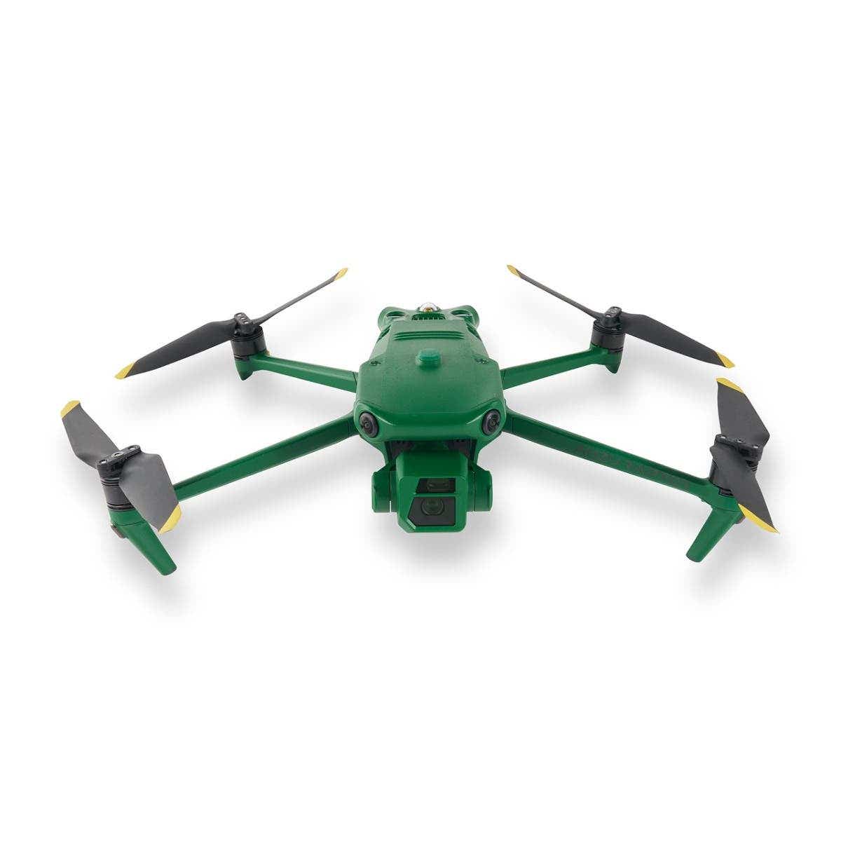
Elevate Your Mission with the Anzu Raptor
The Anzu Raptor is a cutting-edge drone solution crafted to meet the precise demands of industry professionals. Designed and manufactured in the United States, it prioritizes national security, data privacy, and exceptional performance.
Backed by advanced imaging capabilities, unparalleled flight endurance, and seamless operational flexibility, the Anzu Raptor empowers users to excel in specialized fields such as agriculture, search and rescue, and infrastructure inspection.
Precision, Power, and Security
Unrivaled Imaging Technology
-
High-Resolution Visuals: The Anzu Raptor is equipped with a 48MP primary camera, capturing sharp, detailed images to meet the highest professional standards.
-
56x Hybrid Zoom: Enables precise imaging from significant distances, perfect for inspections and surveillance.
This state-of-the-art imaging system ensures that professionals can collect critical data with accuracy and confidence.
Endurance and Efficiency
-
Extended Flight Time: Operates for up to 45 minutes on a single charge, allowing you to cover extensive areas with fewer interruptions.
-
Long Range: With a range of 9 miles, the drone is ideal for expansive missions, from mapping projects to large-scale inspections.
The Anzu Raptor’s focus on flight endurance reduces downtime and enhances overall productivity.
Enhanced Navigation with RTK
-
Centimeter-Level Accuracy: The optional Real-Time Kinematic (RTK) module provides exceptional precision for complex applications.
-
Reliable Navigation: Ideal for demanding environments where precision is critical, such as industrial inspections and resource mapping.
Seamless Integration with Professional Tools
-
Third-Party Compatibility: Works with leading platforms like DroneDeploy and DroneLink, enabling automated mapping and tailored workflows.
The Anzu Raptor’s adaptability ensures it integrates effortlessly into existing professional ecosystems, offering a versatile and efficient solution for your needs.
Security and Compliance You Can Trust
-
Data Privacy: All data is stored securely on U.S.-based servers, addressing concerns about foreign-manufactured technology.
-
FAA Compliance: Includes pre-flight checklists and quick LAANC authorizations, ensuring safe, responsible operation within the National Airspace System.
These robust safety and security features give professionals peace of mind and the assurance of compliant, reliable performance.
Revolutionizing Industries
Public Safety and Emergency Response
-
Search and Rescue Missions: Detect and locate missing persons with advanced imaging and thermal capabilities.
-
Firefighting Operations: Identify hotspots and assist with real-time situational analysis.
-
Law Enforcement: Conduct discreet surveillance and gather critical data for investigations.
Agriculture and Environmental Monitoring
-
Monitor crop health, optimize irrigation, and detect pests or diseases with precision imaging.
-
Survey wildlife habitats and track environmental changes without disrupting ecosystems.
Infrastructure and Industrial Inspections
-
Assess powerlines, pipelines, and other infrastructure for maintenance needs or potential hazards.
-
Inspect buildings, bridges, and other structures with high-resolution visuals and accurate data.
Mapping and Surveying
-
Generate detailed maps for urban planning, construction, and resource management.
-
Conduct aerial surveys with RTK-enabled precision for accurate results.
Whether addressing public safety challenges, enhancing agricultural efficiency, or performing critical infrastructure inspections, the Anzu Raptor adapts to meet the specific demands of each industry.
Why Choose the Anzu Raptor from DSLRPros?
The Anzu Raptor, available at DSLRPros.com, offers cutting-edge features, secure data management, and professional-grade performance tailored for industry professionals. With precision imaging, reliable navigation, and unparalleled versatility, the Anzu Raptor is designed to help you excel in demanding operations.
Ready to elevate your capabilities? Explore the Anzu Raptor here at DSLRPros.com and discover how this advanced drone can revolutionize your workflow.
The DSLRPros Advantage
At DSLRPros, our mission is to provide cutting-edge drone solutions for diverse industries.
- Tailored Applications: Specialized for sectors like agriculture, safety, and energy.
- Insightful Expertise: We understand and address industry-specific challenges.
- Innovative Equipment: Featuring drones like DJI Phantom with advanced features.
- Reliable Data Solutions: GDPR-compliant systems built for efficiency.
- Supportive Training: Equipping you with tools and knowledge to succeed.
We combine technology, expertise, and support to drive results.
Specifications
Aircraft
- Weight (with propellers, without accessories): DJI Mavic 3E: 915 g | DJI Mavic 3T: 920 g
- Max Takeoff Weight: DJI Mavic 3E: 1,050 g | DJI Mavic 3T: 1,050 g
- Dimensions: Folded (without propellers): 221×96.3×90.3 mm (L×W×H) | Unfolded (without propellers): 347.5×283×107.7 mm (L×W×H)
- Diagonal Distance: 1 mm
- Max Ascent Speed: 6 m/s (Normal Mode) | 8 m/s (Sport Mode)
- Max Descent Speed: 6 m/s (Normal Mode) | 6 m/s (Sport Mode)
- Max Flight Speed (at sea level, no wind): 15 m/s (Normal Mode) | Forward: 21 m/s, Side: 20 m/s, Backward: 19 m/s (Sport Mode)
- Max Wind Speed Resistance: 12 m/s
- Max Take-off Altitude Above Sea Level: 6000 m (without payload)
- Max Flight Time (no wind): 45 mins
- Max Hover Time (no wind): 38 mins
- Max Flight Distance: 32 km
- Max Tilt Angle: 30° (Normal Mode) | 35° (Sport Mode)
- Max Angular Velocity: 200°/s
- GNSS: GPS+Galileo+BeiDou+GLONASS (GLONASS is supported only when the RTK module is enabled)
- Hovering Accuracy: Vertical: ±0.1 m (with Vision System); ±0.5 m (with GNSS); ±0.1 m (with RTK) | Horizontal: ±0.3 m (with Vision System); ±0.5 m (with High-Precision Positioning System); ±0.1 m (with RTK)
- Operating Temperature Range: -10° to 40° C (14° to 104° F)
- Internal Storage: N/A
- Motor Model: 2008
- Propeller Model: 9453F Propellers for Enterprise
- Beacon: Built into the aircraft
Wide Camera
- Sensor: DJI Mavic 3E: 4/3 CMOS, Effective pixels: 20 MP | DJI Mavic 3T: 1/2-inch CMOS, Effective pixels: 48 MP
- Lens: DJI Mavic 3E: FOV: 84°; Format Equivalent: 24 mm; Aperture: f/2.8-f/11; Focus: 1 m to ∞ | DJI Mavic 3T: FOV: 84°; Format Equivalent: 24 mm; Aperture: f/2.8; Focus: 1 m to ∞
- ISO Range: DJI Mavic 3E: 100-6400 | DJI Mavic 3T: 100-25600
- Shutter Speed: DJI Mavic 3E: Electronic Shutter: 8-1/8000 s; Mechanical Shutter: 8-1/2000 s | DJI Mavic 3T: Electronic Shutter: 8-1/8000 s; Max Image Size; DJI Mavic 3E: 5280×3956; DJI Mavic 3T: 8000×6000
- Still Photography Modes: DJI Mavic 3E: Single: 20 MP; Timed: 20 MP; JPEG: 0.7/1/2/3/5/7/10/15/20/30/60 s; JPEG+RAW: 3/5/7/10/15/20/30/60 s; Smart Low-light Shooting: 20 MP; Panorama: 20 MP (raw image) | DJI Mavic 3T:
- Single: 12 MP/48 MP; Timed: 12 MP/48 MP; JPEG: 2/3/5/7/10/15/20/30/60 s*; Panorama: 12 MP (raw image); 100 MP (stitched image); Smart Low-light Shooting: 12 MP | * Shooting 48MP photo does not support 2s interval
- Video Resolution:264 | 4K: 3840×2160@30fps | FHD: 1920×1080@30fps
- Bitrate: DJI Mavic 3E: 4K: 130 Mbps; FHD: 70 Mbps | DJI Mavic 3T: 4K: 85 Mbps; FHD: 30 Mbps
- Supported File Formats: exFAT
- Photo Format: DJI Mavic 3E: JPEG/DNG (RAW) | DJI Mavic 3T: JPEG
- Video Format: MP4 (MPEG-4 AVC/H.264)
Tele Camera
- Sensor: 1/2-inch CMOS, Effective pixels: 12 MP
- Lens: FOV: 15° | Format Equivalent: 162 mm | Aperture: f/4.4 | Focus: 3 m to ∞
- ISO Range: DJI Mavic 3E: 100-6400 | DJI Mavic 3T: 100-25600
- Shutter Speed: Electronic Shutter: 8-1/8000 s
- Max Image Size: 4000×3000
- Photo Format: JPEG
- Video Format: MP4 (MPEG-4 AVC/H.264)
- Still Photography Modes: DJI Mavic 3E: Single: 12 MP; Timed: 12 MP; JPEG: 0.7/1/2/3/5/7/10/15/20/30/60 s; Smart Low-light Shooting: 12 MP | DJI Mavic 3T:
- Single: 12 MP; Timed: 12 MP; JPEG: 2/3/5/7/10/15/20/30/60 s; Smart Low-light Shooting: 12 MP
- Video Resolution: H.264 | 4K: 3840×2160@30fps | FHD: 1920×1080@30fps
- Bitrate: DJI Mavic 3E: 4K: 130 Mbps; FHD: 70 Mbps | DJI Mavic 3T: 4K: 85 Mbps; FHD: 30 Mbps
- Digital Zoom: 8x (56x hybrid zoom)
Thermal Camera
- Thermal Imager: Uncooled VOx Microbolometer
- Pixel Pitch: 12 μm
- Frame Rate: 30 Hz
- Lens: DFOV: 61° | Format Equivalent: 40 mm | Aperture: f/1.0 | Focus: 5 m to ∞
- Sensitivity: ≤50 mk@F1.1
- Temperature Measurement Method: Spot Meter, Area Measurement
- Temperature Measurement Range: -20° to 150° C (-4° to 302° F, High Gain Mode) | 0° to 500° C (32° to 932° F, Low Gain Mode)
- Palette: White Hot/Black Hot/Tint/Iron Red/Hot Iron/Arctic/Medical/Fulgurite/Rainbow 1/Rainbow 2
- Photo Format: JPEG (8-bit) | R-JPEG (16-bit)
- Video Resolution: 640×512@30fps
- Bitrate: 6 Mbps
- Video Format: MP4 (MPEG-4 AVC/H.264)
- Still Photography Modes: DJI Mavic 3T: Single: 640×512; Timed: 640×512; JPEG: 2/3/5/7/10/15/20/30/60 s
- Digital Zoom: 28x
- Infrared Wavelength: 8-14 μm
- Infrared Temperature Measurement Accuracy: ±2° C or ±2% (using the larger value)
Gimbal
- Stabilization: 3-axis (tilt, roll, pan)
- Mechanical Range: DJI Mavic 3E: Tilt: -135° to 100°; Roll: -45° to 45°; Pan: -27° to 27° | DJI Mavic 3T: Tilt: -135° to 45°; Roll: -45° to 45°; Pan: -27° to 27°
- Controllable Range: Tilt: -90° to 35° | Pan: Not controllable
- Max Control Speed (tilt): 100°/s
- Angular Vibration Range: ±0.007°
Sensing
- Type: Omnidirectional binocular vision system, supplemented with an infrared sensor at the bottom of the aircraft.
- Forward: Measurement Range: 0.5-20 m| Detection Range: 0.5-200 m | Effective Sensing Speed: Flight Speed ≤15 m/s| FOV: Horizontal 90°, Vertical 103°
- Backward: Measurement Range: 0.5-16 m | Effective Sensing Speed: Flight Speed ≤12 m/s | FOV: Horizontal 90°, Vertical 103°
- Lateral: Measurement Range: 0.5-25 m | Effective Sensing Speed: Flight Speed ≤15 m/s | FOV: Horizontal 90°, Vertical 85°
- Upward: Measurement Range: 0.2-10 m | Effective Sensing Speed: Flight Speed ≤6 m/s | FOV: Front and Back 100°, Left and Right 90°
- Downward: Measurement Range: 0.3-18 m | Effective Sensing Speed: Flight Speed ≤6 m/s | FOV: Front and Back 130°, Left and Right 160°
- Operating Environment: Forward, Backward, Lateral, and Upward: Surface with a clear pattern and adequate lighting (lux >15) | Downward: Diffuse reflective surface with diffuse reflectivity>20% (e.g. walls, trees, people) and adequate lighting (lux >15)
Video Transmission
- Video Transmission System: DJI O3 Enterprise Transmission
- Live View Quality: Remote Controller: 1080p/30fps
- Operating Frequency:400-2.4835 GHz | 5.725-5.850 GHz
- Max Transmission Distance (unobstructed, free of interference): DJI Mavic 3E: FCC: 15 km; CE: 8 km; SRRC: 8 km; MIC: 8 km | DJI Mavic 3T: FCC: 15 km; CE: 8 km; SRRC: 8 km; MIC: 8 km
- Max Transmission Distance (Obstructed): Strong Interference (dense buildings, residential areas, etc.): 1.5-3 km (FCC/CE/SRRC/MIC) | Medium Interference (suburban areas, city parks, etc.): 3-9 km (FCC), 3-6 km (CE/SRRC/MIC) | Low Interference (open spaces, remote areas, etc.): 9-15 km (FCC), 6-8 km (CE/SRRC/MIC)
- Max Download Speed: 15 MB/s (with DJI RC Pro Enterprise)
- Latency (depending on environmental conditions and mobile device): 200 ms
- Antenna: 4 Antennas, 2T4R
- Transmission Power (EIRP): 4 GHz: <33 dBm (FCC), <20 dBm (CE/SRRC/MIC) | 5.8 GHz: <33 dBm (FCC), <30 dBm (SRRC), <14 dBm (CE)
DJI RC Pro Enterprise
- Video Transmission System: DJI O3 Enterprise Transmission
- Max Transmission Distance (unobstructed, free of interference): FCC: 15 km | CE/SRRC/MIC: 8 km
- Video Transmission Operating Frequency:400-2.4835 GHz | 5.725-5.850 GHz
- Antenna: 4 Antennas, 2T4R
- Video Transmission Transmitter Power (EIRP):4 GHz: <33 dBm (FCC), <20 dBm (CE/SRRC/MIC) | 5.8 GHz: <33 dBm (FCC), <14 dBm (CE), <23 dBm (SRRC)
- Wi-Fi Protocol:11 a/b/g/n/ac/ax | Support 2×2 MIMO Wi-Fi
- Wi-Fi Operating Frequency:400-2.4835 GHz | 5.150-5.250 GHz | 5.725-5.850 GHz
- Wi-Fi Transmitter Power (EIRP):4 GHz: <26 dBm (FCC), <20 dBm (CE/SRRC/MIC) | 5.1 GHz: <26 dBm (FCC), <23 dBm (CE/SRRC/MIC) | 5.8 GHz: <26 dBm (FCC/SRRC), <14 dBm (CE)
- Bluetooth Protocol: Bluetooth 5.1
- Bluetooth Operating Frequency: 400-2.4835 GHz
- Bluetooth Transmitter Power (EIRP): < 10 dBm
- Screen Resolution: 1920×1080
- Screen Size:5 inches
- Screen: 60 fps
- Brightness: 1,000 nits
- Touchscreen Control: 10-point multi-touch
- Battery: Li-ion (5000 mAh @ 7.2 V)
- Charging Type: Recommended to be charged with the included DJI USB-C Power Adapter (100W) or USB charger at 12 V or 15 V
- Rated Power: 12 W
- Storage Capacity: Internal Storage (ROM): 64 GB | Supports a microSD card for expanded capacity.
- Charging Time: 1 hour 30 minutes (with the included DJI USB-C Power Adapter (100W) only charging the remote controller or a USB charger at 15 V) | Approx. 2 hours (with a USB charger at 12 V) | Approx. 2 hours 50 minutes (with the included DJI USB-C Power Adapter (100W) charging the aircraft and remote controller simultaneously)
- Operating Time: 3 hours
- Video Output Port: Mini-HDMI port
- Operating Temperature Range: -10° to 40° C (14° to 104° F)
- Storage Temperature: -30° to 60° C (-22° to 140° F) (within one month) | -30° to 45° C (-22° to 113° F) (one to three months) | -30° to 35° C (-22° to 95° F) (three to six months) | -30° to 25° C (-22° to 77° F) (more than six months)
- Charging Temperature: 5° to 40° C (41° to 104° F)
- Supported DJI Aircraft: DJI Mavic 3E | DJI Mavic 3T
- GNSS: GPS+Galileo+GLONASS
- Dimensions: Antennas folded and controller sticks unmounted: 183.27×137.41×47.6 mm (L×W×H) | Antennas unfolded and controller sticks mounted: 183.27×203.35×59.84 mm (L×W×H)
- Weight: 680 g
- Model: RM510B
Storage
- Supported Memory Cards: Aircraft: U3/Class10/V30 or above is required. A list of recommended microSD cards can be found below.
- Recommended microSD Cards: Remote Controller: SanDisk Extreme PRO 64GB V30 A2 microSDXC; SanDisk High Endurance 64GB V30 microSDXC; SanDisk Extreme 128GB V30 A2 microSDXC; SanDisk Extreme 256GB V30 A2 microSDXC; SanDisk Extreme 512GB V30 A2 microSDXC; Lexar 667x 64GB V30 A2 microSDXC; Lexar High-Endurance 64GB V30 microSDXC; Lexar High-Endurance 128GB V30 microSDXC; Lexar 667x 256GB V30 A2 microSDXC; Lexar 512GB V30 A2 microSDXC; Samsung EVO Plus 64GB V30 microSDXC; Samsung EVO Plus 128GB V30 microSDXC; Samsung EVO Plus 256GB V30 microSDXC; Samsung EVO Plus 512GB V30 microSDXC; Kingston Canvas Go! Plus 128GB V30 A2 microSDXC; Kingston Canvas React Plus 128GB V90 A1 microSDXC | Aircraft: SanDisk Extreme 32GB V30 A1 microSDHC; SanDisk Extreme PRO 32GB V30 A1 microSDHC; SanDisk Extreme 512GB V30 A2 microSDXC; Lexar 1066x 64GB V30 A2 microSDXC; Kingston Canvas Go! Plus 64GB V30 A2 microSDXC; Kingston Canvas React Plus 64GB V90 A1 microSDXC; Kingston Canvas Go! Plus 128GB V30 A2 microSDXC; Kingston Canvas React Plus 128GB V90 A1 microSDXC; Kingston Canvas React Plus 256GB V90 A2 microSDXC; Samsung PRO Plus 256GB V30 A2 microSDXC
Battery
- Capacity: 5000 mAh
- Standard Voltage:4 V
- Max Charging Voltage:6 V
- Type: LiPo 4S
- Chemical System: LiCoO2
- Energy: 77 Wh
- Weight:5 g
- Charging Temperature: 5° to 40° C (41° to 104° F)
Charger
- Input: 100-240 V (AC Power), 50-60 Hz, 2.5 A
- Output Power: 100 W
- Output: 100 W (total) | When both ports are used, the maximum output power of each interface is 82 W, and the charger will dynamically allocate the output power of the two ports according to the load power.
Charging Hub
- Input: USB-C: 5-20 V, 5.0 A
- Output: Battery Port: 12-17.6 V, 8.0 A
- Rated Power: 100 W
- Charging Type: Three batteries charged in sequence
- Charging Temperature Range: 5° to 40° C (41° to 104° F)
RTK Module
- Dimensions:2×40.2×66.2 mm (L×W×H)
- Weight: 24±2 g
- Interface: USB-C
- Power: 1.2 W
- RTK Positioning Accuracy: RTK Fix: Horizontal: 1 cm + 1 ppm; Vertical: 1.5 cm + 1 ppm
Speaker
- Dimensions:1×82.0×54.7 mm (L×W×H)
- Weight: 85±2 g
- Interface: USB-C
- Rated Power: 3 W
- Max Volume: 110 dB @ 1 m
- Effective Broadcast Distance: 100 m @ 70 dB
- Bit Rate: 16 Kbps/32 Kbps
- Operating Temperature Range: -10° to 40° C (14° to 104° F)
In the Box
- 1x Anzu Raptor aircraft
- 1x Controller w/ built-in screen
- 1x Battery
- 1x Charging Station
- 1 Set Propellers
- 1x Hard Case
- Manuals

