


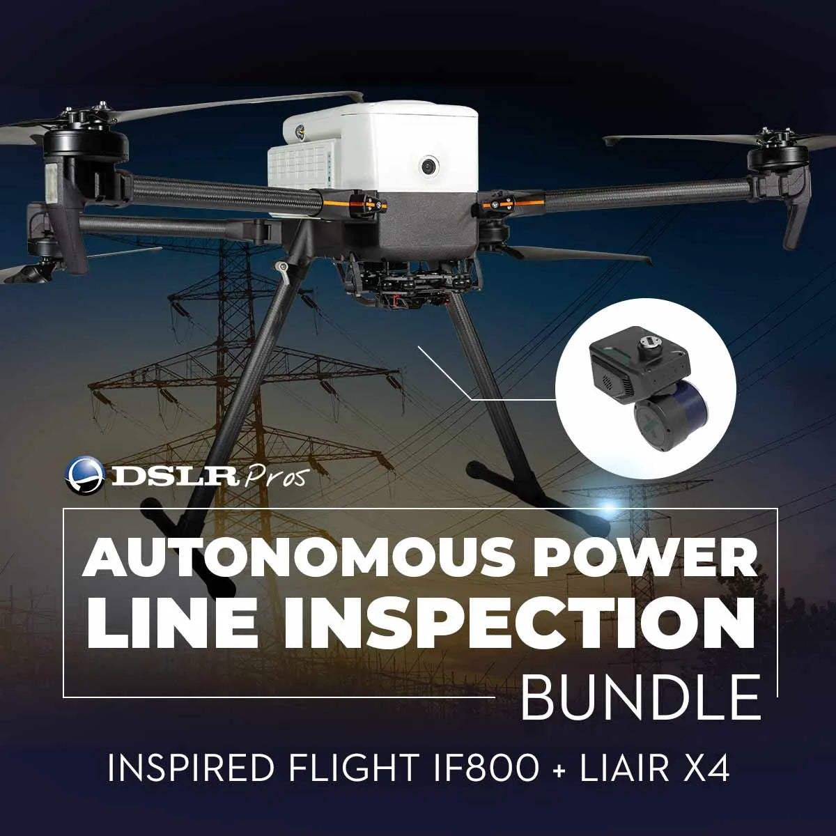
Autonomous Power Line Inspection Bundle: Inspired Flight IF800 + LiAir X4
The Autonomous Power Line Inspection Bundle combines the cutting-edge Inspired Flight IF800 TOMCAT drone with the powerful LiAir X4 LiDAR system and LiPower Line software. This all-in-one package revolutionizes power line inspections by automating processes, reducing costs, and improving safety. The IF800 TOMCAT is a medium-lift quadcopter designed for professional applications, featuring a compact, foldable frame, up to 54-minute flight time, and a payload capacity of 1.5 kg (max 3 kg). Dual hot-swappable batteries enable continuous operations, while a 60-degree upward-angle shooting capability ensures versatile data capture.
Paired with the LiAir X4 LiDAR system, this bundle captures high-precision data, enabling the detection of faults, sagging lines, and vegetation interference. The included LiPower Line software simplifies data analysis and generates detailed reports, enhancing infrastructure monitoring and preventive maintenance. Perfect for power utilities and inspection firms, this bundle ensures efficient operations, reduces manual labor risks, and improves decision-making with actionable insights.
Key Features
-
Inspired Flight IF800 TOMCAT Drone
- 54-Minute Flight Time: Extended flight capabilities with a 1.5 kg payload allow for comprehensive inspections without the need for frequent battery swaps.
- Foldable and Compact Frame: Easily transportable and quick to deploy in various environments, increasing operational flexibility.
- Dual Hot-Swappable Batteries: Seamless battery swaps reduce downtime and keep operations running smoothly.
- 60-Degree Upward-Angle Shooting: Captures unique perspectives for inspecting power lines and hard-to-reach infrastructure.
- NDAA & Blue UAS Compliant: Ensures secure, reliable operations for both commercial and government use.
Blue Herelink Ground Control Station
-
- 20 km Flight Range: Long-distance control with AES-128 encryption for secure communications.
- HD Video Feed: Live video streaming for real-time situational awareness and precision flight control.
- Multifunction Interface: Combines manual flight, auto-mission programming, and live data viewing in one device.
-
LiAir X4 LiDAR System
- High-Precision Data Collection: Detects faults, sagging lines, and vegetation interference with industry-leading accuracy.
- Lightweight Design: Optimized for the IF800 TOMCAT drone, maximizing flight efficiency without sacrificing performance.
-
LiPower Line Software
- Automated Analysis: Simplifies complex data into actionable insights, reducing the time required for analysis.
- Detailed Reporting: Generate comprehensive reports for stakeholders to streamline decision-making and maintenance planning.
Use Cases
-
Power Line Inspection: Automate the detection of faults, sagging lines, and vegetation interference, ensuring faster and safer inspections compared to manual methods.
-
Infrastructure Monitoring: Maintain electrical grids effectively by identifying potential issues early, helping to prevent outages and service disruptions.
-
Preventive Maintenance: Schedule repairs proactively by identifying issues before they escalate, reducing downtime and enhancing system reliability.
-
Data Analysis and Reporting: Leverage LiPower Line software to convert raw data into detailed, easy-to-understand reports for stakeholders, improving communication and planning.
-
Cost Reduction: Minimize labor costs and the risks associated with traditional manual inspections, making operations more efficient and safer.
Why Choose the Autonomous Power Line Inspection Bundle
This bundle offers an all-in-one solution designed to enhance the efficiency, safety, and accuracy of power line inspections. The Inspired Flight IF800 TOMCAT drone provides reliable, long-duration flights with its durable, foldable frame and hot-swappable batteries, ensuring minimal downtime. The LiAir X4 LiDAR system delivers precise, high-resolution data crucial for identifying issues such as sagging lines, faults, and vegetation interference.
With LiPower Line software, data analysis is streamlined, allowing you to generate detailed reports quickly and accurately. Additionally, the NDAA and Blue UAS compliance ensures secure operations, making this bundle ideal for commercial and government use cases. The inclusion of the Blue Herelink Ground Control Station with a 20 km range and encrypted communication further enhances control and security, making this package a comprehensive, future-ready solution for power line inspections.
Invest in the Autonomous Power Line Inspection Bundle today to streamline your inspection processes, improve operational efficiency, and ensure the safety and reliability of your infrastructure. Explore smarter, safer, and more cost-effective inspections now at DSLRPros!
Specifications
Performance
- Max Ascent Speed: 5 m/s (16 ft/s)
- Max Descent Speed: 3 m/s (10 ft/s)
- Max Air Speed: 22 m/s (49 mph)
- Max Wind Resistance: 10 m/s, 12 m/s gusts (19 knots, 23 knot gusts)
- Max Tilt Angle: 30°
- Max Angular Velocity: Tilt: 300°/s, Yaw: 120°/s
- Operating Temperature: -20°C ~ 45°C (-4°F ~ 113°F)
- Operating Humidity: IP43 5% ~ 99%
Physical Features
- Diagonal Size (propeller center to center): 905 mm (35.6 inches)
- Unfolded Size (flight ready, WxLxH): 132 x 114 x 52 cm (51.8 x 44.8 x 20.3 inches)
- Folded Size (stow, WxLxH): 36 x 44 x 20 cm (14.2 x 17.4 x 7.8 inches)
- Empty Weight (w/o batteries): 4.2 kg (9.2 lbs)
- Weight w/ Batteries: 8.5 kg (18.7 lbs)
- Max Gross Takeoff Weight: 11.5 kg (25.3 lbs)
- Max Payload Capacity: 3.0 kg (6.6 lbs)
- Transport Case Size (WxLxH): 52.8 x 80.7 x 31.7 cm (20.8 x 31.8 x 12.5 inches)
- Transport Case Weight (w/ aircraft & GCS): 18 kg (40 lbs)
Flight Stack
- Flight Controller: CubePilot Cube Blue H7, Triple Redundant IMU
- GNSS / Compass: Dual CubePilot Here4 Blue
- Downward Ground Sensor: LightWare SF000/B
- Payload Power Rails: 6s Battery Voltage 5v, 12v, 18v
- Payload Interface: IF800 Universal Payload Interface
- Operating Software: Copter by Ardupilot
Flight Modes
- Position Hold: Automatically holds altitude and position, manually change position
- Loiter: Holds altitude and position, precision manual movements using GPS
- Auto: Executes pre-defined waypoint mission
- RTL: Auto returns to takeoff location and lands
- Land: Auto land while maintaining horizontal position
- Altitude Hold: Holds altitude only, failsafe mode if GPS signal lost
In The Box
- Drone: Inspired Flight IF800 + LiAir X4
- Add-ons: 3x Batteries, LiAir X4 LiDAR System, LiPower Line Software

