


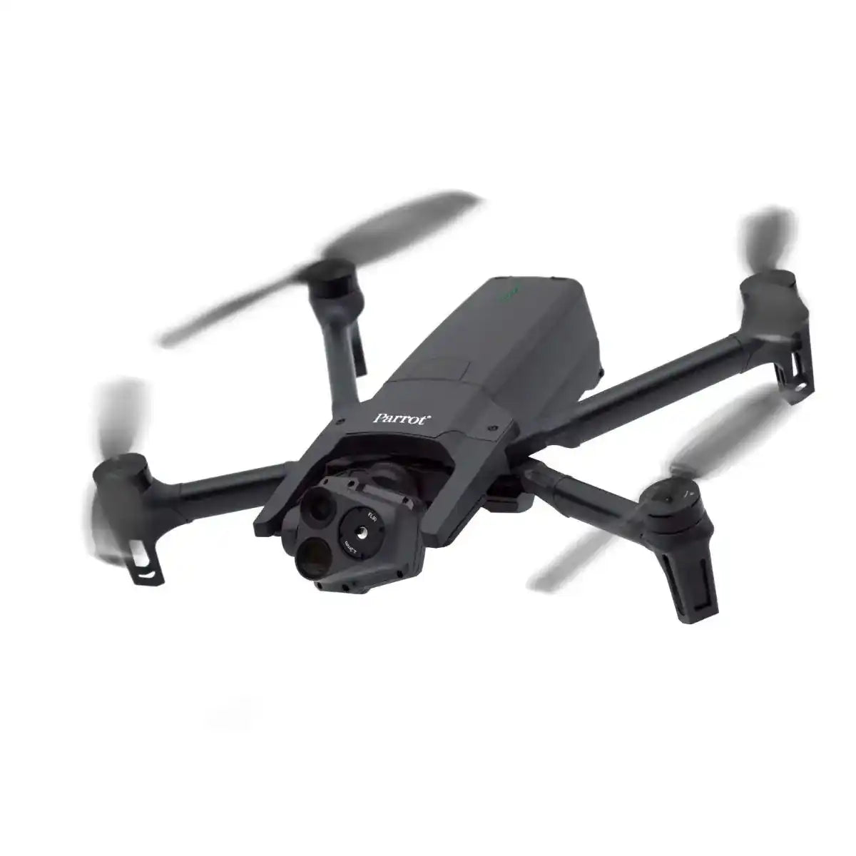


Parrot ANAFI USA: Redefining Emergency Response and Professional Operations
Deliver groundbreaking solutions with the Parrot ANAFI USA, a drone built to meet the rigorous demands of professionals in firefighting, search and rescue, security, and environmental monitoring. Built in collaboration with the US Army, its lightweight, compact, and versatile design ensures unmatched performance in diverse and challenging conditions.
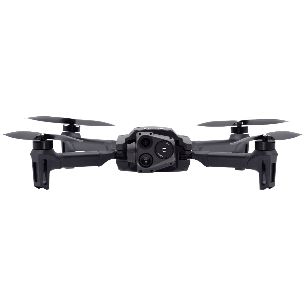
See More, Achieve More: Advanced Imaging and Optics
Discover the power of cutting-edge imaging technology with the Parrot Anafi USA. Designed to capture every detail, it provides professionals with the tools needed for precise assessments and actionable insights.
- Capture Critical Details: Utilize the 32x optical zoom for sharp, high-resolution visuals, allowing operators to assess situations from up to 3 miles away.
- Detect Heat Signatures: The FLIR Boson® thermal camera pinpoints hotspots and human presence up to 2 km away, providing valuable insights for firefighting and search-and-rescue missions.
- Experience Stabilized Clarity: Achieve smooth, stable footage with a combination of gimbal stabilization and 3-axis digital image processing, even in dynamic environments.
- Wide-Angle Precision: Balance detailed close-ups with broad situational awareness to monitor large areas effectively.
Equip your team with unparalleled imaging capabilities to make informed decisions in any environment.
Rapid Deployment When Every Second Counts
Act fast when it matters most. The Anafi USA is built for rapid response, ensuring professionals are ready for critical operations in seconds.
- Deploy Quickly: Be mission-ready in under 55 seconds, ensuring fast response times for critical operations.
- Fly Anywhere: Operate in both indoor and outdoor environments with GPS precision and no built-in no-fly zone restrictions.
- Quiet Efficiency: With a noise level of just 79 dB, the Anafi USA enables stealth operations while minimizing disruptions.
- Travel Light: Fold the 500g drone into a compact size for ultimate portability, making it easy to carry and deploy anywhere.
Trust Anafi USA to deliver speed, efficiency, and reliability when every second counts.
Built for the Toughest Missions
Take on harsh environments with confidence. The Anafi USA’s rugged design ensures durability and consistent performance for demanding operations.
- Weather-Resistant: IP53 certification ensures durability in rain, dust, and harsh conditions.
- Extended Flight Time: Stay in the air longer with a 32-minute battery life, maximizing operational efficiency.
- Universal Charging: Recharge quickly and easily using a USB-C charger, ideal for field operations.
- Precision Control: Utilize the FreeFlight 6 app to define flight routes, execute autonomous missions, and track targets effortlessly.
Designed to withstand the toughest conditions, the Anafi USA delivers reliability you can count on.
Made in the USA: Secure Data, Trusted Operations
Safeguard every aspect of your data with advanced security measures. Exceed industry standards while integrating seamlessly with professional workflows.
- Protect Mission Data: Encrypt photos and videos on the SD card to safeguard sensitive information.
- Ensure Secure Communication: Utilize WPA2 Wi-Fi encryption and signed firmware to verify and protect links between the drone and controller.
- GDPR Compliance: Keep data private by default, with user-controlled sharing through secure servers in Europe.
- Streamlined Sharing: Leverage the FreeFlight 6 app for seamless data handling and enhanced mission collaboration.
Secure mission integrity and data privacy with robust measures built for professional use.
Maximize Workflow Efficiency
Streamline operations with tools designed to optimize productivity and enhance collaboration. The Anafi USA simplifies complex workflows for better results.
- Instant Mapping: Transform captured images into accurate 2D maps using Pix4Dreact, empowering teams with real-time insights.
- Integrate with Industry Tools: Access a wide ecosystem of professional apps and services through an open-source SDK and standardized protocols.
- Plan Smarter Missions: Automate flight plans with pre-set routes and target tracking for coordinated team operations.
Maximize your team’s potential with innovative tools that enhance productivity and mission success.
Elevating Industry Standards
Redefine professional workflows with powerful imaging and data capture capabilities tailored for critical missions. Experience versatility across various sectors.
Firefighting and Emergency Response
- Locate victims and assess hazardous areas with real-time thermal and optical imaging.
- Detect hotspots up to 2 km away to enhance firefighting efficiency.
- Capture and share mission-critical data to streamline rescue operations.
Infrastructure and Security Assessments
- Inspect essential assets like bridges, powerlines, and towers with 32x zoom and 4K visuals.
- Protect operations with secure WPA2 Wi-Fi connections and encrypted SD cards.
- Execute autonomous inspection routes for seamless workflows.
Agriculture and Environmental Monitoring
- Monitor crop health and environmental changes with high-resolution imaging.
- Generate instant 2D maps using Pix4Dreact for actionable insights.
- Track wildlife and manage natural resources effectively.
Search and Rescue Operations
- Enhance situational awareness with rapid deployment and superior imaging capabilities.
- Track missing persons or hazardous materials with advanced technology.
- Perform reliably in harsh environments with IP53 weather resistance.
Elevate mission success with tools that deliver precision, speed, and adaptability.
Why Choose Parrot ANAFI USA?
Equip professionals with unparalleled imaging, rapid deployment, and advanced flight capabilities. Rugged design, secure data handling, and versatile functionality make it an essential tool for emergency responders, inspectors, and environmental monitors.
Redefine possibilities in the field by choosing the Parrot ANAFI USA.
The DSLRPros Advantage
DSLRPros delivers reliable, high-performing drone solutions built for industry needs.
- Custom Solutions: Designed for public safety, agriculture, construction, and more.
- Sector Expertise: Every product is tailored to meet your operational challenges.
- Quality Equipment: Offering leading drones like the DJI Phantom for peak performance.
- Safe Data Handling: Tools that prioritize security and compliance.
- End-to-End Support: Training to ensure you maximize your drone investment.
We bring expertise, innovation, and support to every solution we offer.
Specifications
Drone
- Size (folded): 252 × 104 × 84 mm
- Size (unfolded): 282 × 373 × 82 mm
- Size (unfolded on MIL version): 282 × 373 × 192 mm
- Mass: 500 g / 1.10 lb
- Maximum Take-off Mass (MTOM): 644 g / 1.42 lb
- Maximum Flight Time: 32 minutes (30 minutes on MIL version)
- Maximum Horizontal Speed: 14.7 m/s
- Maximum Ascent Speed: 4 m/s (6 m/s on unlocked SE, GOV, and MIL versions)
- Maximum Descent Speed: 3 m/s
- Maximum Wind Resistance: 14.7 m/s
- Maximum Propeller Speed: 11,000 rpm
- Sound Power Level at 1 m (3 ft): 84 dB
- Service Ceiling: 5,000 m above MSL (Mean Sea Level)
- User Defined Geofencing: Supported
- IP Rating: IP53 (dust and rain resistant)
- Operating Temperature: -33 °F (-36 °C) to +122 °F (+50 °C)
- No Take-off Temperature Limitations: Supported
Security
- Zero Data Shared by Default: Supported
- SD Card Encryption: AES-XTS encryption with a 512 bits key
- Network Connections: WPA2 AES CCMP encrypted
- Firmware: Digitally signed
Sensors
- Satellite Navigation: GPS, GLONASS, & GALILEO
- Barometer and Magnetometer: Supported
- Vertical Camera and Ultra-sonar: Supported
- IMU: 2 × 6-axis
- Accelerometers: 2 × 3-axis
- Gyroscopes: 2 × 3-axis
EO Image Chain
- Sensors: 2 sensors (1/2.4")
- Digital Zoom: 32x
- Electronic Shutter Speed: 1 s to 1/10,000 s
- ISO Range: 100 - 3200
- Video Resolution: 4K/FHD/HD
- Video Format: MP4 (H.264)
-
Photo Resolutions:
- Wide: 21 MP (84° FOV)
- Rectilinear: up to 16 MP (up to 75.5° FOV)
- Photo Formats: JPEG, DNG (Digital NeGative RAW)
IR Image Chain
- Sensor: FLIR BOSON
- Digital Zoom: 32x
- Temperature Range: -40°C to +150°C
- Thermal Sensitivity: ≤60 mK
- Measured IR Wavelength Range: 7.5 to 13 micrometers
- Video Resolution: 1280 × 720 px
- Video Format: MP4 (H.264)
- Framerate: 9 fps
- Photo Resolution: 320 × 256 px
- Photo Format: JPEG
Image Stabilization
- Stabilized Gimbal: 3-camera IR/EO
- Hybrid Stabilization: 3-axis
- Mechanical Stabilization: 2-axis roll/pitch
- Electronic (EIS): 3-axis pitch/roll/yaw
- Controllable Gimbal Tilt Range: -90° to +90°
Fast-Charging Smart Battery
- Type: High density LiPo (3 × 4.4 V cells)
- Capacity: 3,400 mAh
- Battery Life: 32 minutes
- Charging Port: USB-C
- Charging Time: Charges in 2 h with a USB-PD (Power Delivery) charger
- Mass: 195 g / 0.43 lb
- Voltage: 11.55 V
- Maximum Charging Power: 30 W
Parrot Skycontroller 4
- Size (without device): 238 × 147 × 55 mm
- Maximum Size: 315 × 147 × 55 mm
- Mass: 610 g / 1.34 lb
- Transmission System: Wi-Fi 802.11 a/b/g/n
- Operating Frequencies: 2.4 GHz, UNII-1 & UNII-3
- Direct Video Stream Resolution: 720p
- Battery Capacity: 3,350 mAh 7.2 V
- Charging Time: 3 h 45 min
- Battery Life: Between 3 h and 6 h (varies according to the device used and its state of charge)
- Compatibility: Compatible with all smartphones and tablets up to 8"
- Ports: 2 × USB-C (charging and connecting), micro-HDMI
- IP Rating: IP5X (dust resistant)
Parrot Skycontroller USA
- Size: 313 × 208 × 72 mm
- Size (with antenna unfolded on MIL version): 313 × 208 × 173 mm
- Mass: GOV version: 1.14 kg / 2.51 lbs, MIL version: 1.16 kg / 2.56 lbs
- NDAA & TAA Compliant: Supported
- Transmission System: Wi-Fi 802.11 a/b/g/n (+ additional Microhard radio on MIL version)
- Operating Frequencies: 2.4 GHz, UNII-1 & UNII-3
- Direct Video Stream Resolution: 720p
- Battery Capacity: 5,000 mAh 7.2 V
- Charging Time: 2 h
- Battery Life: 4 h 30 min
- Based On: 8" Samsung Galaxy Tab A
- Ports: USB-C, USB-A, Ethernet
- IP Rating: IP53 (dust and rain resistant)
ANAFI USA MIL
- Radio: Microhard pDDL1800 1.8 GHz
- TOGA (Tactical Open Government Architecture) Compatible: Supported
- Foldable Antennas: Supported
- AES 256 Encryption: Supported
- Additional Mass: 20 g on ANAFI USA; 20 g on the Skycontroller USA
Ecosystem
- Open Source SDK for Developers: Supported
- Extensive Partner Program: Supported
In the Box
- 1x ANAFI USA drone
- 3x smart batteries (3x32 minutes)
- 1x Skycontroller 4
- 1x tablet holder
- 1x multi-port fast USB charger
- 1x additional set of propeller blades
- 4x USB-A/USB-C cables
- 1x hard case

