


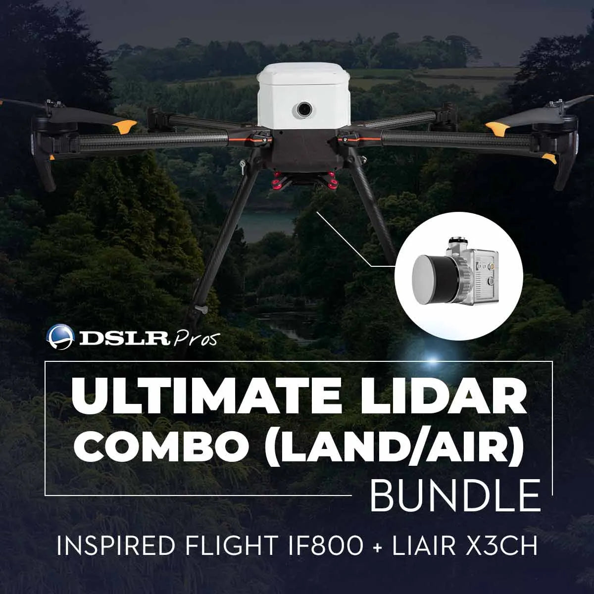
DSLRPros Ultimate LiDAR Combo (Land/Air): Inspired Flight IF800 + LiAir X3CH
The Ultimate LiDAR Combo (Land/Air) combines the versatility of the Inspired Flight IF800 TOMCAT Drone and the LiAir X3CH LiDAR System with a handheld attachment and powerful LiDAR360 software. This comprehensive solution allows seamless transition between aerial and ground-based LiDAR mapping, making it ideal for topographic surveys, forestry management, urban planning, and archaeological exploration. With advanced flight capabilities, high-precision LiDAR, and intelligent data processing tools, this bundle offers everything needed for reliable and efficient data collection.
The IF800 TOMCAT features a foldable frame, up to 54 minutes of flight time, and dual hot-swappable batteries for uninterrupted missions. The LiAir X3CH provides detailed 3D point clouds with a 26MP camera and a detection range of up to 300 meters. Whether you’re flying overhead or scanning from the ground, this combo ensures high accuracy and comprehensive coverage. With LiDAR360 software, you can process, analyze, and visualize your data seamlessly, turning raw scans into actionable insights.
Key Features
Inspired Flight IF800 TOMCAT Drone
- 54-Minute Flight Time: Extended missions with a 1.5 kg payload capacity (max 3 kg).
- Foldable and Portable Design: Lightweight and compact for easy transport and quick deployment.
- Dual Hot-Swappable Batteries: Minimize downtime with seamless battery changes.
- 60-Degree Upward-Angle Shooting: Capture data from unique perspectives.
- Blue Herelink Ground Control Station: 20 km range, AES-128 encryption, and live HD video.
- NDAA & Blue UAS Compliant: Secure operations for commercial and government use.
LiAir X3CH LiDAR System
- High Precision Scanning: Detect objects up to 300 meters with 90% reflectivity.
- 26MP Camera: Capture high-resolution images for detailed visual analysis.
- Lightweight Design: Weighs just 1.12 kg for optimized drone flight performance.
- Multiple Return Rates: Up to 1,920,000 points per second for comprehensive 3D mapping.
LiDAR360 Software
- Advanced Data Processing: Analyze, visualize, and manage LiDAR data efficiently.
- Automated Analysis Tools: Preprocessing, classification, and vectorization features.
- Industry-Specific Solutions: Tailored for forestry, topography, powerline inspection, and more.
Handheld Attachment
- Ground-Based Scanning: Easily switch to handheld mode for detailed ground-level mapping.
- Versatile Operation: Complete flexibility for both aerial and terrestrial LiDAR collection.
Use Cases
-
Versatile LiDAR Mapping: Seamlessly switch between aerial and ground-based scanning for comprehensive coverage.
-
Topographic Surveys: Generate high-resolution 3D models for civil engineering, construction, and land development projects.
-
Forestry Management: Assess forest structure, biomass, and canopy density for sustainable resource management.
-
Urban Planning: Create accurate maps of urban environments to inform development and infrastructure projects.
-
Archaeological Exploration: Reveal hidden structures and artifacts without excavation using high-precision LiDAR.
Why Choose the DSLRPros Ultimate LiDAR Combo (Land/Air)
This combo offers unmatched versatility and precision for LiDAR mapping. The Inspired Flight IF800 TOMCAT ensures reliable aerial operations with extended flight time, a portable design, and secure compliance. The LiAir X3CH LiDAR System delivers detailed and accurate point clouds, whether mounted on the drone or used handheld. LiDAR360 software simplifies data processing, offering robust tools for analysis, visualization, and reporting. Ideal for professionals in surveying, forestry, urban planning, and archaeology, this bundle streamlines workflows, reduces operational downtime, and ensures high-quality results.
Take your LiDAR mapping to the next level with this powerful, versatile solution. Order the Ultimate LiDAR Combo (Land/Air) today at DSLRPros and experience seamless aerial and ground-based data collection!
Specifications
Performance
- Max Ascent Speed: 5 m/s (16 ft/s)
- Max Descent Speed: 3 m/s (10 ft/s)
- Max Air Speed: 22 m/s (49 mph)
- Max Wind Resistance: 10 m/s, 12 m/s gusts (19 knots, 23 knot gusts)
- Max Tilt Angle: 30°
- Max Angular Velocity: Tilt: 300°/s, Yaw: 120°/s
- Operating Temperature: -20°C ~ 45°C (-4°F ~ 113°F)
- Operating Humidity: IP43 5% ~ 99%
Physical Features
- Diagonal Size (propeller center to center): 905 mm (35.6 inches)
- Unfolded Size (flight ready, WxLxH): 132 x 114 x 52 cm (51.8 x 44.8 x 20.3 inches)
- Folded Size (stow, WxLxH): 36 x 44 x 20 cm (14.2 x 17.4 x 7.8 inches)
- Empty Weight (w/o batteries): 4.2 kg (9.2 lbs)
- Weight w/ Batteries: 8.5 kg (18.7 lbs)
- Max Gross Takeoff Weight: 11.5 kg (25.3 lbs)
- Max Payload Capacity: 3.0 kg (6.6 lbs)
- Transport Case Size (WxLxH): 52.8 x 80.7 x 31.7 cm (20.8 x 31.8 x 12.5 inches)
- Transport Case Weight (w/ aircraft & GCS): 18 kg (40 lbs)
Flight Stack
- Flight Controller: CubePilot Cube Blue H7, Triple Redundant IMU
- GNSS / Compass: Dual CubePilot Here4 Blue
- Downward Ground Sensor: LightWare SF000/B
- Payload Power Rails: 6s Battery Voltage 5v, 12v, 18v
- Payload Interface: IF800 Universal Payload Interface
- Operating Software: Copter by Ardupilot
Flight Modes
- Position Hold: Automatically holds altitude and position, manually change position
- Loiter: Holds altitude and position, precision manual movements using GPS
- Auto: Executes pre-defined waypoint mission
- RTL: Auto returns to takeoff location and lands
- Land: Auto land while maintaining horizontal position
- Altitude Hold: Holds altitude only, failsafe mode if GPS signal lost
System Specifications
-
Detection Range:
- 80 m (reflectivity ≥ 10%)
- 200 m (reflectivity ≥ 54%)
- 300 m (reflectivity ≥ 90%)
- 80 m (reflectivity ≥ 10%)
- Accuracy (Vertical): 5 cm @ 70m
- Typical Flight Speed: 5-10 m/s
- Weight: 1.12 kg
- Memory: 256 GB TF Card
- Voltage: 12~24 V
- Power Consumption: 24 W
- Operating Temperature: -20~50 ℃
- Storage Temperature: -30~60 ℃
Communication: WIFI
LiDAR Unit
- Wavelength: 905 nm
- Number of Channels: 32
-
Point Rate:
- First Return: 640,000 points/s
- Dual Return: 1,280,000 points/s
- Triple Return: 1,920,000 points/s
- First Return: 640,000 points/s
- FOV: 360° (Horizontal)×40.3° (Vertical)
- Number of Returns: 3
Inertial Navigation System
- GNSS: GPS, GLONASS, Galileo, BD
- Azimuth Accuracy: 0.038°
- Attitude Accuracy: 0.008°
- IMU Data Frequency: 200 Hz
Camera
- Pixels: 26 Megapixels
- Image Size: 6252×4168
- Focal Length: 16 mm / 24 mm (Equiv. Focal Length)
Software
- Pre-processing: LiGeoreference
- Post-processing: LiDAR360 / LiPowerline (Optional)
Compatible Platforms
Platforms: DJI, Freefly, etc.
In The Box
- Drone: Inspired Flight IF800
- Add-ons: LiAir X3CH LiDAR System, Handheld Attachment, 3x Batteries, LiDAR360 Software

